Modern urban infrastructure is transforming public safety in measurable ways, from preventing pedestrian injuries to detecting threats in real time. This article examines nineteen concrete applications where cities have deployed smart systems to protect residents, drawing on case studies and expert analysis from safety engineers, urban planners, and municipal technology leaders. Each example demonstrates how targeted infrastructure improvements address specific risks that traditional approaches have struggled to solve.
- Integrate Discreet Barriers To Shield Crowds
- Target Hazard Zones With Responsive Streetlight Networks
- Coordinate Traffic Control To Limit Collisions
- Automate Flood Closures To Avert Entrapment
- Sense Rockfalls Early With Fiber Optics
- Sync Sensors Lights And Citizen Reports
- Route Contagious Patients Outside Shared Spaces
- Consolidate Incident Information For Faster Updates
- Equip Buildings To Safeguard Occupants Automatically
- Build An Integrated Corridor That Learns
- Detect Gunfire And Illuminate Scenes Instantly
- Calibrate Corridors For Safer Clinic Visits
- Organize The Curb To Prevent Injuries
- Reduce Slips With Adaptive Boardwalk Conditions
- Extend Crosswalk Time For Vulnerable Pedestrians
- Stop Wrong Way Entries With Layered Alerts
- Adapt Signals To Cut Crash Risk
- Fuse City Feeds For Proactive Police Work
- Cable Link Restores Community Access
Integrate Discreet Barriers To Shield Crowds
One project that comes to my mind is the Salesforce Transit Center project in San Francisco. The project encompasses the Salesforce Tower, a major transportation hub, and a 5 acre rooftop public park known as the “Park in the Sky.” It’s a strong example of how smart infrastructure has improved public safety while still creating an open and welcoming community gathering place.
At Delta Scientific, we supplied more than 800 crash-rated bollards throughout the site to help secure the perimeter around the transit center, tower, and elevated public park. The project called for a balance of high security, with the physical realities of a dense urban environment. The project had to accommodate commuters, pedestrians, public events, emergency access, and recreational space all within the same footprint.
The system we put in incorporated a combination of fixed and retractable bollards and crash barricades engineered to stop errant vehicles from entering the public spaces. We incorporated smart retractable bollards for when staff and authorized personnel need temporary access.
The incorporation of security into the architecture was what made the project so successful. The bollards are ADA friendly. When the objective is to achieve protection without making your community feel unwelcome, this can be a challenge.
The rooftop park is an especially important part of the story because it shows how physical security can protect highly active community spaces. Thousands of people use the park every week, and the perimeter protection helps safeguard both the critical infrastructure below, and the community destination above it.
To me, that’s a strong example of smart infrastructure. It’s one where strong security measures are thoughtfully integrated, communities are safer and public spaces remain inviting.

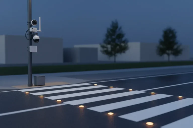
Target Hazard Zones With Responsive Streetlight Networks
An instance is an upgraded form of smart street luminaire performing as an integrated light sensor network to enhance pedestrian safety in high-risk areas, such as near schools; at transport terminals; and at poorly lit intersections. The project was not simply implemented as “better lighting”, rather, the key component of this new installation was a combination of the use of motion detection sensors, adaptive lighting, and incident reporting data in order to establish a responsive community for how citizens move through that neighbourhood.
In particular, this new smart infrastructure featured LED streetlights that brightened according to approaching pedestrians or cyclists; used CCTV or camera-integrated monitoring within priority zones; included environmentally-based sensors; and created a central dashboard linking councils or operational teams. This allowed maintenance teams to quickly identify failure points; police or safety teams to identify repeat incidents within defined areas; and planners to adapt lighting and/or pedestrian crossings according to the actual pattern of use.
My lessons learned are that the best approach for smart infrastructure is first to define the public safety threat or hazard and then use technology as the means to continue that workflow. Focus on where the hazard zones exist; do not simply install more smart devices.

Coordinate Traffic Control To Limit Collisions
One clear example comes from Los Angeles, where the Automated Traffic Surveillance and Control (ATSAC) system has significantly improved public safety on busy urban roads.
ATSAC is a smart traffic management infrastructure project that uses a network of roadway sensors, closed-circuit cameras, and real-time data analytics to monitor traffic conditions across the city. At its core, the system continuously adjusts traffic signal timings based on live congestion patterns rather than fixed schedules. This adaptive control helps reduce bottlenecks that often contribute to accidents at intersections.
A key safety feature is emergency vehicle preemption. When ambulances, fire trucks, or police vehicles are en route, the system can automatically change traffic signals to create a clear path, reducing response times during critical emergencies. In addition, operators at a centralized traffic management center can view live video feeds and intervene quickly when incidents occur.
The impact has been notable: fewer intersection collisions, smoother traffic flow, and faster emergency response times—especially in high-density corridors. What makes the system effective is not a single technology, but the combination of real-time sensing, automated decision-making, and human oversight working together to make streets safer.

Automate Flood Closures To Avert Entrapment
One practical example is a flood prone underpass equipped with water level sensors, connected signage, roadway cameras, and automated route alerts to transit operators and the public. Before the upgrade, drivers often entered the area too late to turn around, and buses could be diverted only after conditions became obvious. The smart infrastructure reduced that delay by triggering warnings and closures the moment thresholds were crossed, which prevented vehicle entrapment and reduced emergency response risk.
What makes this notable is that the technology protected safety by improving decision timing. I often tell engineering leaders that public trust depends on whether a system is predictable in bad conditions, not impressive in normal ones. In transportation, resilient communications, validated sensor inputs, and clear fallback behavior are the features that quietly save lives when weather and traffic combine.

Sense Rockfalls Early With Fiber Optics
Rockfalls present a critical and growing threat to railway safety and reliability. These unpredictable natural hazards can cause catastrophic accidents, endangering the lives of staff, passengers and leading to severe damage to rolling stock and vital infrastructure. The dangers extend beyond the immediate collision; a derailment caused by a rockfall can also lead to the release of hazardous materials from freight wagons, posing severe environmental and public health risks.
With increasingly extreme weather patterns linked to climate change, the frequency and severity of these geological events are on the rise and rail routes through these regions are increasingly turning to new monitoring capabilities such as Distributed Acoustic Sensing which effectively turns fiber optic cables into arrays of thousands of sensors listening to infrastructure whilst spanning great distances.
The Distributed Acoustic Sensing (DAS) technology we deliver (at Sensonic) offers real-time detection and location of rockfalls along entire rail routes. By continuously monitoring for the acoustic signatures of impacts from falling rocks, our system delivers crucial, near-instantaneous warnings, enabling operators to act and mitigate these challenging risks.
Our detection systems operate across several countries, but some of the accidents prevented are captured in our rogues gallery here – https://www.sensonic.com/en/natural-hazard-rockfall/#gallery
The safety improvements for both passengers are hopefully pretty obvious!
The technology that powers these solutions might seem sci-fi, but I try to explain it in simple terms along with a short video/animation here: https://www.sensonic.com/en/blog/what-is-distributed-acoustic-sensing-how-does-it-work–3274/. The technology has been used in oil and gas pipelines for monitoring for many years and is also branching out into other infrastructure monitoring areas such as water leak detection and seismic monitoring too.

Sync Sensors Lights And Citizen Reports
I’ve seen some incredible smart infrastructure projects through my work at Free QR Code AI, but one that really stands out is Barcelona’s smart lighting and emergency response system. A few years back, the city deployed over 19,000 smart LED streetlights equipped with sensors that detect movement, air quality, and even unusual sound patterns like gunshots or crashes. When I first read about it, I immediately thought about how we could integrate QR codes at emergency stations to help citizens report incidents quickly.
The system automatically brightens lights in areas where people are walking at night, which alone reduced street crime by about 30% in pilot zones. The sensors connect to a central IoT platform that alerts emergency services the moment something seems off. Response times dropped significantly because the system can pinpoint exact locations and even guide responders through connected digital signage.
What I find really clever is how they tied everything together with mobile apps. Citizens can scan QR codes on streetlights to report issues, access safety information, or signal distress. We’ve actually helped several municipalities implement similar QR-based reporting features at Free QR Code AI, and the engagement rates are remarkable. People don’t want to download yet another app, but they’ll absolutely scan a QR code in an emergency.
The project also included environmental monitoring that tracks flooding risks in real time, giving early warnings to residents in vulnerable areas. Barcelona proved that when you combine sensor networks, connected lighting, mobile technology, and simple interfaces like QR codes, you create something greater than the sum of its parts. Public safety isn’t just about cameras and police anymore. It’s about creating an environment where technology quietly works in the background to prevent problems before they happen and respond instantly when they do.

Route Contagious Patients Outside Shared Spaces
At The Family Doctor in Tucson, smart infrastructure shows up less as citywide sensors and more as the small communication systems that keep patients safer day to day, so I’ll share the closest example I can speak to honestly: how we used connected tools to improve public safety during respiratory illness season.
A few seasons back, we leaned on a simple “smart” setup to get ahead of flu spread in our community. The key pieces were straightforward: a secure scheduling system tied to same/next-day appointment slots, SMS reminders for annual flu shots, and direct cell access to the doctor so symptomatic patients could be triaged before they ever sat in a waiting room. That last piece is the underrated public safety feature. When a patient can text or call directly, we can route a contagious person to a house call or a parking-lot visit instead of a shared lobby, which protects every other family on the schedule.
The technology itself wasn’t flashy: encrypted messaging, a cloud-based scheduling tool, and reminder automations. What made it work was tying it to our direct-pay model. Because we aren’t routing through insurance, we can act on a text in minutes instead of days, and we can offer wholesale-priced labs or rapid testing without a billing delay that might keep someone home and undiagnosed.
For other small practices or community groups thinking about “smart” safety projects, my advice is to start where the friction is highest. Map the moments when a delay creates risk, a sick kid waiting for a callback, a traveler needing vaccines before a flight, a senior unsure whether to drive in, and put your connected tools there first. Fancy dashboards are nice, but a reliable text thread, a shared calendar, and a clear escalation path will move the safety needle further in a neighborhood clinic than almost any enterprise platform. Trust and speed are the real infrastructure.

Consolidate Incident Information For Faster Updates
Most of the “smart infrastructure” work we saw at Big Drop Inc. was less about futuristic city tech and more about fixing broken connections between old systems. One project with a regional public agency stood out. It was an emergency information platform that sat on top of multiple outdated databases, all giving slightly different answers depending on where you looked.
Residents would check a hotline, then the website, then a social feed, and get three versions of the same instruction. Internally it was worse. Staff were using separate tools that did not sync, and nobody was fully sure which source was “official” during live incidents.
The goal was not to add more data. It was to make the existing information reliable and consistent under pressure. That is what actually affects public safety, not more dashboards.
The biggest improvement came in how quickly accurate updates could reach people during emergencies. In one storm response simulation in Florida, the lag between an internal update and public visibility dropped from hours to minutes. That alone changed how teams operated. Call center staff stopped relying on outdated PDFs and handwritten notes because everything pointed back to one live source.
The setup behind it was fairly unglamorous. API connections stitched legacy systems into a single public facing portal. A centralized content system replaced scattered static files. Role based access meant emergency staff could publish updates directly without waiting on developers. We also built real time syncing between internal dashboards and the public site, with redundancy so one failure would not break the whole chain.
What usually caused problems before that was inconsistency, not missing technology. Outdated contact details sitting in forgotten systems, or teams unsure which dataset to trust in a crisis. Leadership often assumed new software would fix it, but we had to map actual workflows first before any technical change made sense.
The takeaway was simple. Public safety improves when information moves clearly and quickly, not when systems look advanced. If staff hesitate or doubt what they are seeing, everything slows down. I would take a boring, reliable system over something impressive that fails under pressure every time.

Equip Buildings To Safeguard Occupants Automatically
Smart infrastructure that actually moves the needle on public safety usually comes down to one thing: catching problems before they hurt somebody. The clearest example I point to from our world at Accurate Home and Commercial Services is the wave of smart accessibility and energy-monitoring systems being built into newer commercial properties around the Greater Houston area. We see them firsthand during TAS/ADA and IECC inspections.
One Conroe-area commercial build we walked recently had networked occupancy sensors tied to emergency egress lighting, smart smoke and CO detectors that pinged building management directly, and automated door operators on ADA-compliant entries. When power dipped during a storm, the system rerouted egress lighting, unlocked accessible exits, and pushed alerts to the property manager’s phone before anyone on site even noticed. That is public safety in action, a building that protects the people inside without waiting for someone to flip a switch.
The key features I’d highlight: IoT sensors with redundant power, integrated fire and life-safety panels that talk to mobile devices, ADA-compliant automated egress, and energy systems verified through REScheck and COMcheck so the building performs the way the drawings promise. The accessibility piece matters more than people realize; in an emergency, an unpowered door or a non-compliant route is a public safety failure, not just a code violation.
What we tell builders and property owners is simple: smart tech only improves safety if it’s installed correctly and verified by a third party. We pair our TDLR Registered Accessibility Specialist work with energy and general inspections so the systems actually function as designed. Technology is the headline, but verification is what keeps the community safe long after the ribbon-cutting.

Build An Integrated Corridor That Learns
I’m Runbo Li, Co-founder & CEO at Magic Hour.
The example that sticks with me is what happened in Kansas City when they rolled out their smart corridor along the streetcar line around 2016. They installed connected LED streetlights, environmental sensors, and free public Wi-Fi across a 2.2-mile stretch downtown. The public safety impact was immediate and measurable.
The key feature wasn’t any single sensor. It was the integration layer. Connected streetlights with adaptive brightness meant dark corridors disappeared. When pedestrian traffic increased in an area, the lights responded in real time. They paired that with video analytics that could detect anomalies, things like a person lying motionless on a sidewalk or unusual crowd density, and route alerts to first responders faster than a 911 call.
What made it work wasn’t the technology alone. It was that the city treated infrastructure as a platform, not a one-time purchase. The sensors generated data that fed into traffic management, emergency response routing, and even helped urban planners understand where to invest next. One system informed the other. That compounding effect is what separates a “smart” project from just an expensive one.
The parallel to what we see in AI is striking. The communities and companies that win aren’t the ones buying the fanciest tool. They’re the ones building feedback loops where data from one system makes the next decision better. Kansas City didn’t just install lights. They built an infrastructure nervous system.
The takeaway: smart infrastructure isn’t about the hardware. It’s about whether the system gets smarter over time or just sits there depreciating. If your investment doesn’t compound, it’s not smart, it’s just new.

Detect Gunfire And Illuminate Scenes Instantly
I’ve worked with municipalities through Local SEO Boost, and one project that really stands out involved a smart gunshot detection system paired with automated streetlight technology in a mid-sized city near us.
The system used acoustic sensors mounted on buildings and light poles throughout high-crime neighborhoods. When gunshots were detected, the technology pinpointed the exact location within seconds and automatically alerted police dispatch with precise coordinates. The streetlights in the immediate area would simultaneously flash brighter, illuminating the scene and helping witnesses see what was happening.
The key technologies involved were acoustic triangulation sensors, IoT-connected LED streetlights with variable brightness controls, and a centralized AI platform that distinguished actual gunfire from fireworks or car backfires. False alarm rates dropped significantly compared to older systems.
I spoke with the police chief at a chamber of commerce event where we were presenting local search strategies. He told me response times improved by roughly 35% because officers knew exactly where to go instead of searching vague areas based on panicked 911 calls. The illuminated streets meant witnesses could provide better descriptions, which led to more arrests.
The city also integrated the system with traffic cameras that automatically locked onto detected locations, giving dispatchers real-time video before officers even arrived. That intelligence helped first responders prepare appropriately for what they were walking into.
Within the first year, shootings in covered areas dropped nearly 20%, likely because criminals knew the technology was active. The community felt safer, local businesses saw evening foot traffic increase.
Smart infrastructure isn’t just about convenience. When done right, it genuinely saves lives.

Calibrate Corridors For Safer Clinic Visits
Smart infrastructure isn’t our world at Davila’s Clinic, we run a primary care practice in Weslaco, TX, but I can share how a local public safety improvement directly shaped how we serve patients, and the lesson translates.
A few years back, the City of Weslaco upgraded several intersections along Texas Boulevard and the corridors leading toward our area with smarter traffic signals, better-timed pedestrian crossings, and improved street lighting. From our vantage point at 412 E 18th ST, the impact on patient safety was real and measurable in the kind of visits we see. Fewer pedestrian near-misses in the evenings, easier access for older patients walking in for wellness check-ups, and noticeably calmer arrivals for families coming to evening appointments during our extended 5:00 PM to 9:00 PM hours.
The key features that mattered most to a clinic like ours were three things: adaptive signal timing that responded to actual traffic flow instead of fixed cycles, brighter LED lighting that made our parking area and the surrounding streets safer after dark, and clearer pedestrian signaling for patients with mobility challenges or chronic conditions who can’t sprint across a crosswalk.
What I’d tell any community planner thinking about smart infrastructure is the same thing we tell patients when we explain tradeoffs in a care plan: the flashy technology matters less than whether it actually changes daily behavior for the people using it. We saw the win not in a press release but in patients telling us they finally felt comfortable booking a 7:30 PM telemedicine follow-up or driving in for a physical check-up after work.
Public safety and public health overlap more than people realize. Safer streets mean patients keep appointments, manage chronic conditions consistently, and engage in preventive care, which is ultimately what keeps a community healthier long-term.

Organize The Curb To Prevent Injuries
A mid-sized city cut pedestrian injury risk by redesigning several nightlife district intersections with smart curb management and real-time traffic analytics. The area had recurring incidents after evening events because rideshare pickups, delivery vehicles, and foot traffic were all competing for the same curb space. The city introduced geofenced loading zones, adaptive signal timing, and camera-based pedestrian counts that shifted street operations by time of day.
That project stood out because it treated the curb as a safety asset instead of just a parking edge. We found the biggest improvement came when pickup activity was organized before it spilled into travel lanes, which reduced sudden stops, unsafe crossings, and distracted turning behavior.

Reduce Slips With Adaptive Boardwalk Conditions
A waterfront boardwalk project is a good example because the safety challenge involved weather, low light and unpredictable public use rather than a single obvious hazard. Traditional lighting alone would not have solved the problem, since glare on wet surfaces can actually make depth perception worse. We saw better results from a design that responded to conditions in real time.
The boardwalk used low glare pathway lighting, moisture sensing, handrail illumination and environmental monitoring linked to alerts for maintenance teams. During high wind or poor visibility, the system shifted lighting levels and activated warning indicators at access points. That approach improved footing, reduced slip risk and helped the space remain usable without compromising public awareness.

Extend Crosswalk Time For Vulnerable Pedestrians
An excellent example is Singapore’s smart elder friendly crossings, where pedestrians can tap a card to receive extra crossing time at selected intersections. The technology is simple, but the safety impact is significant because it recognizes that one standard signal cycle does not serve every user equally. Longer walk phases reduce mid crossing anxiety and lower the chance of someone being stranded as vehicles begin moving.
I think the project stands out because it respects real human behavior. Public safety improves when infrastructure adapts to vulnerability instead of forcing vulnerable people to adapt to speed. Personalized timing, clear signals, and intuitive access made intersections safer without adding friction for the broader traffic network.

Stop Wrong Way Entries With Layered Alerts
One compelling example involved a regional highway interchange with frequent wrong-way entries. Transportation teams installed radar detection, thermal cameras, red-light flashers, and connected alerts. When a vehicle entered from the wrong ramp, warnings activated immediately. I regard that as lifesaving infrastructure because seconds determine crash severity.
The strongest feature was layered communication across drivers, operators, and enforcement teams. Nearby signs warned oncoming traffic while control centers tracked vehicle movement. Police received precise location data instead of vague reports from callers. Safety improved because the system shortened detection, notification, and intervention at once.

Adapt Signals To Cut Crash Risk
In Missouri there was an adaptive traffic signal project carried out by the Missouri Department of Transportation (MoDOT) along Route 291 in Lee’s Summit. In this project, MoDOT implemented adaptive traffic signal technology along a 2.5-mile stretch containing 12 signalized intersections due to ongoing congestion and traffic crashes in the area.
In this project, smart cameras, intelligent signal controllers, and fiber optic communication between intersections were used to monitor traffic flow in real time. The adaptive system responded to changes in traffic volume and helped minimize delays and uncoordinated traffic conditions. The implementation of the system led to reductions in travel time, delays, fuel consumption, emissions, and the number of stops experienced by drivers along that corridor.
Fewer stops help minimize the risk of accidents as well as aggressive driving behaviors. In addition, projects like this promote roadway safety because they reduce congestion. As a personal injury lawyer, I believe these types of projects are significant because many intersection accidents occur when traffic systems fail to adapt to actual traffic conditions.
Smart infrastructure projects allow cities and transportation authorities to identify potential risks in real time and take action before accidents occur.

Fuse City Feeds For Proactive Police Work
Caveat: I’m a UK marketing-agency founder rather than a public-safety operator, but my agency has tracked smart-city projects in client adjacencies and the public-safety improvements have a consistent pattern. A specific example:
The example: London’s CCTV-integrated public safety network combined with the connected sensor layer in central boroughs, particularly the deployment around Westminster and the West End.
The mechanic. Pre-implementation, public safety in dense urban areas relied on dispersed monitoring — independent CCTV systems run by different boroughs, traffic cameras run by Transport for London, environmental sensors run by air quality teams, emergency services dispatching from radio-based systems. Each information source operated in isolation. When an incident occurred, responding officers had to assemble a picture from multiple disconnected sources, often with significant delay.
What the smart-infrastructure layer changed. Three operational improvements. (1) Cross-feed correlation — when a CCTV camera detects an incident, the system simultaneously pulls relevant traffic camera feeds, nearby sensor data (air quality if relevant, crowd density measurements from Wi-Fi sensors), and emergency services dispatch status. Officers arrive with situational context the dispersed system could not have produced. (2) Predictive deployment — pattern analysis across the consolidated data identifies areas of likely incident concentration. Patrol resources deploy to where the data predicts they’ll be needed rather than uniformly. (3) Post-incident analytics — incident investigations now produce evidence chains that combine multiple data sources, accelerating case resolution.
The privacy-tradeoff caveat. This kind of consolidation does create surveillance concerns that the UK has been working through via regulatory frameworks. The safety benefit is real; the civil-liberties trade-off is also real and deserves continued scrutiny.
The single principle. Smart infrastructure improves public safety when it consolidates the information picture officers and responders work from. The technology is enabling; the practical benefit is faster, better-informed decisions during incidents.

Cable Link Restores Community Access
For example, the Metrocable in Medellin, Colombia. The feature is a kind of cable car that links poor communities in the hills with the city’s main rail lines.
Not only did it move people around; this project really made the area safer. It aided individuals who resided in faraway places to get to work, school, doctors, and parks much more easily. The city improved the areas near the different stations by ensuring there were bright lights, parks, libraries, and safe paths for walking.
E.g., most high, steep hills are not accessible to ordinary buses or trains; cable cars fill this need. However, the best part was marrying transit with community services.
The lesson here is simple. The right solution to problems in a neighborhood might be to build what makes people feel seen — and safe. This was not an alternate route that Medellin constructed. They provided people with a genuine connection to the rest of their city.


